Skyline

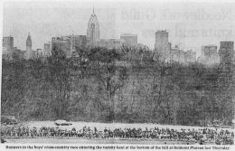
Observing the 1987 Philadelphia Skyline via Vintage Photographs

Since 1987, the Philadelphia skyline has expanded both horizontally and vertically, as the city has received a new tallest skyscraper along with multiple towers rising higher than 500 feet. However, over 30 years ago, the skyline was already suggesting what was coming in the future, as skyscrapers were finally rising above the 548-foot mark set by City Hall in Center City. In this feature, Philadelphia YIMBY will look back at the skyline by observing photographs from 1987.

Read More

Philadelphia skyline from the Commodore Barry Bridge. Photo by Thomas Koloski

YIMBY Observes The Philadelphia Skyline From The Commodore Barry Bridge

Many of the iconic points for observing the Philadelphia skyline are located in the city, though several are situated in New Jersey across the Delaware River and on the multiple bridges that connect New Jersey and Pennsylvania. One of these is the Commodore Barry Bridge, which was completed in 1974. Today, Philadelphia YIMBY observes the rising Philadelphia skyline from the bridge.

Read More

Philadelphia 1905 and 2020 south elevation. Photo by Thomas Koloski

Looking Back At The Creation Of The Philadelphia Massing

For over a year, Philadelphia YIMBY has been providing extensive publications and visuals depicting new developments planned for the future as well as notable towers that have risen in the past. We have offered images from drawn schematics, custom-made renderings, and skyline massings to give the public a clear look at the structures featured. Any time new high-rise buildings have been revealed or design changes were made, YIMBY reports on the changes with three-dimensional skyline views from various directions. In this feature, we look back at the creation of the 3D skyline massings that we continue to provide to this day.

Read More

Philadelphia 1945 aerial looking east. Models and image by Thomas Koloski

Observing the “Chinese Wall” Rail Viaduct on the 1945 Cityscape

In the late 1800s, the city of Philadelphia made a bold move that greatly transformed and influenced both mass transit and the cityscape when they allowed Pennsylvania Railroad to construct a massive rail viaduct in Center City. One of the largest transportation projects in the city, dubbed to citizens as the “Chinese Wall” due to its appearance and presence, had a dramatic effect on the city’s planning for years to come. Designed by the Wilson Brothers, the rail line stood next to Broad Street Station, which sat on the current site of Dilworth Park, and stretched out all the way to West Philadelphia. The structure saw busy rail service for decades, yet it ultimately met its fate in 1953 after it was demolished to make way for future development. Today YIMBY presents an exclusive massing mock-up of how the structure appeared on the cityscape in 1945.

Read More

Philadelphia skyline from the Walt Whitman Bridge September 2021. Photo by Thomas Koloski

YIMBY Observes the Arthaus, The Laurel Rittenhouse, and the Rising Philadelphia Skyline from the Walt Whitman Bridge

A few months ago, during the beginning of spring, Philadelphia YIMBY published a feature that looked at major developments in Center City from the Walt Whitman Bridge. This 378-foot-tall, green-painted suspension bridge was completed in 1957, and has since transported millions of people between Pennsylvania and New Jersey. The bridge span rises 153 feet above the Delaware River, and offers a fantastic view of the skyline to the northwest. The western side connects to the sports complex in South Philadelphia, while the east side joins Gloucester City, NJ. In this new feature, Philadelphia YIMBY presents an updated look at several major developments in the skyline as seen from the bridge.

Read More

Fetching more...